Travelling to Orléans
HLPP2001: International Workshop on
High-level Parallel Programming and Applications
26-27 March 2001,
Université d'Orléans, France
Château de la Source
Note: Clocks go forward one hour at 01.00 on Sunday 25 March!
To Paris by air:
Most international flights land at Roissy-CDG airport north
of Paris. The simplest and cheapest transport from
there is
the RER
(suburban train, not to be confused with the
underground "metro", or with the TGV or other inter-city trains).
Find the RER station at CDG and reach the Austerlitz ("SNCF")
train station in Paris. Instructions for reaching Orléans
from Austerlitz are below.
If your flight arrives at Orly airport (south of Paris) you will
also have to take a bus or RER to central Paris and reach the
Austerlitz station.
There is no public transport from Orly direct to Orléans.
Practical information about Paris airports can be found on the
Aéroports de Paris web page.
To Paris by train:
Times and fares of all trains to Paris can be found on the
SNCF web page.
The
Thalys page
gives details of services from the Netherlands, Belgium,
Germany, and Swizerland.
For trains from the UK, check
Railtrack
for UK trains and
Eurostar for the
London-Paris service.
The cheapest Eurostar fares must be booked at least 14 days in
advance.
To Orléans by train:
Express trains run from Paris Gare d'Austerlitz to Orléans.
Gare D'Austerlitz can be reached on
the metro
and
the RER
from all Paris rail stations and from Charles de Gaulle Airport.
(From Gare du Nord or Gare de l'Est take the
metro line 5, direction Place d'Italie -- you will reach
Austerlitz in about 10 minutes.)
There is normally at least one train to Orléans
every hour except in mid-afternoon,
and the journey takes just over an hour. Timetables for the days
immediately before and after the workshop are
here; times for other days and services
can be found on the
SNCF web page.
There are two stations in Orléans -- a central one called
Orléans and a suburban one called Les Aubrais.
Check the departure board in Gare d'Austerlitz; if it lists
Les Aubrais but not Orléans, get off at Les Aubrais and wait
for the shuttle train which will take you to the
central station. The shuttle takes about four minutes and does not require
a separate ticket.
A return fare costs about 200 FF. Tickets are valid on any train, but you
must punch your ticket in one of the orange boxes in the station before
boarding the train.
To Orléans by car:
Coming from greater Paris, find the Périphérique boulevard
(ring road) and reach its southern part. Many highways also circle the
city and you may not have to enter the Périphérique. Find
blue (highway) signs for any of Bordeaux, Nantes, Orléans or Tours. That
will take you onto A10 in direction of Orléans. It then takes about an
hour to reach Orléans; the toll is approx. 50F to be paid on exit. Leave
the highway at the "Orleans centre" exit. From there find the main road
going east into town (same green road sign as Blois but opposite direction).
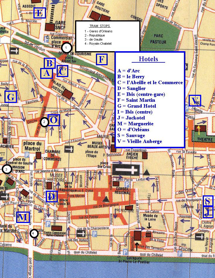
See the
map of Orléans below.
To the Jackotel from Orléans rail station
(Gare SNCF):
(Note that the Jackotel will be our meeting point for an informal
welcome on Saturday evening and the departure point for Sunday's
excursion. Minibusses will take workshop participants to and from the
Jackotel on Monday and Tuesday.)
This is an easy 10-15 minute walk. Cross the boulevards going south on
rue de la République,
towards the Place du Martroi which is recognised by
its equestrian statue (Jeanne d'Arc). From there the Cathedral is visible
on the left (east, do not confuse it with a smaller Church nearby).
Find your way to the Cathedral and then find the east-west
rue de Bourgogne
south of there and parallel to the Cathedral's axis. Walk towards the east
on rue de Bourgogne. You are approximately 3 blocks from
Cloître St-Aignan
which is one block south of rue Bourgogne.
Cloître St-Aignan is in fact a
small public place with a church on its south side. Facing the church is
the entrance to the Jackotel.
See the
map of central Orléans below. "Gare SNCF" is near the top.
To the workshop venue:
The workshop is being held at the Château de la Source at
the Université d'Orléans, which is south of the city.
Minibusses will be provided to take participants to and from the workshop
on Monday and Tuesday.
If you need to travel to or from the Château at other times,
this is easily done by tram.
A tram line connects central Orléans to the University -- trams run
every 5-15 minutes and the trip
takes about half an hour.
The route is shown
here.
Use the
town map below to find a tram stop.
If walking from the Jackotel, just walk westwards on rue de Bourgogne
until you reach the north-south rue Royale (the one connecting
Place du Martroi to the main bridge). You will find the
Royale-Châtelet tram station on that street.
Join the tram in the direction marked
Hôpital de la Source; leave the tram at
Université Château. Use
this campus map to find the Château.
Workshop organisers will have some tram tickets available -- ask if you
need one.


Return to main HLPP2001 page.